| Bathymetric | |
| Side Scan Sonar | |
| Shallow Seismic | |
| Oceanographic | |
| Pipe Route | |
| Sit Investigation | |
HyPack Max - Single Beam Software
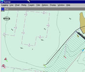
Survey HYPACK® MAX's SURVEY program allows the flexibility and power needed to perform your work. It supports GPS, range-azimuth and range-range navigation systems.
It supports single beam, dual frequency, multiple transducer and multibeam echosounders, along with gyros, magnetometers, telemetry tide gauges and other survey devices.
The SURVEY program can be configured to display and track single vessels, multiple vessels, or the main vessel and ROVs or towfish. Users can display the vessel positions against background files of DXF, DGN, TIF, S-57, BSB, C-Map, or VPF file format.
See more equipment.
To request a call for further information click here.